Table of Contents
Preface
A couple of days back, two terms crossed my mind, and my curiosity levels spiked. The terms were latitude and longitude. Familiar? A world map, lines, dots, hemispheres, etc. would have flashed in your mind, right?
Latitude and longitude post a great geographical significance. They are especially important for sailors and travelers (to remote places) to find the exact location. The latitude and longitude are also used to define important geographical points like the equator, north and south poles, etc. In this post, we will unravel – What are longitude and latitude? Their importance and how are they used?
Latitude & Longitude – Introduction
Latitude and longitude are popular terms when we talk about the location of a place on earth. In times when GPS or any modern technology was not available, latitude and longitude used to come to the rescue. You would have seen in old movies, a pilot, or a ship captain uttering the words like degrees, North, South, etc. for directions. Well, yes, that relates to latitude and longitude.
Latitude and longitude may not be extensively used today due to new technologies. However, they still play an important role in fields like military operations, engineering, navy, airspace, identifying remote regions on the earth, etc. The concept of Latitude and longitude is simple. They can be used in defining and identifying the location of any place on Earth. No limitations or language barriers, just the numbers accepted globally!
Latitude & Longitude Definition and Anatomy
Parallels and Meridians
Before we move further, let us discuss two terms that will help in understanding Latitude and Longitude.
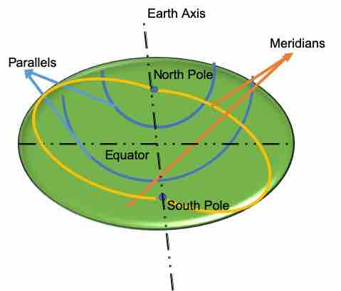
Image 1 (Parallels and Meridians)
Parallels
Considering Earth as a sphere (though it is not a sphere, in reality, a spheroid) Parallels of latitude can be seen as virtual and “near” circular horizontal lines in parallel with the Earth’s Equator and along the surface of the earth. So, Parallels run in the east-west direction parallel to the Equator.
Prime Meridian
Before we move to the longitude, let us discuss on Prime Meridian which acts as a reference for determining the longitude of a place.
The Prime Meridian is considered to have 0 degrees longitude. Prime Meridian could have been chosen anywhere on earth. An important thing to note is Prime Meridian is recognized by every country and supposedly passes through Greenwich, England.
Royal Observatory, Greenwich was recognized by the countries that participated in a convention to identify one standard meridian in 1884.
The Coordinated Universal Time (UTC) set using the Prime Meridian is an International standard time recognized by every country and using which they derive their local standard time.
The Prime Meridian also passes through France, other countries of UK, Spain, and African countries (like Ghana, Tongo, etc.)
Meridians
Similar to the concept of parallels, meridians are virtual and “near” semi-circular lines, perpendicular to all circles of latitude and along the surface of the earth, passing through North and South poles. They are also called Meridians of longitude. Meridians help in identifying a location East or West of the Prime Meridian (an imaginary line passing through the North Pole, South Pole, and Greenwich, London.) Heard of GMT? Yes, the same Greenwich.
Meridians are also called lines of constant longitude.
The Prime Meridian is considered to have 0 degrees longitude.
Latitude and Longitude
Using the concept of Parallels & Meridians, let us try to define latitude and longitude.
Consider Images 2(a) & 2(b). In Image 2(a), the Earth is depicted in a 3D view as seen at a slight angle from the North pole. While in Image 2(b), a 2D view of the latitude and longitude values are shown.
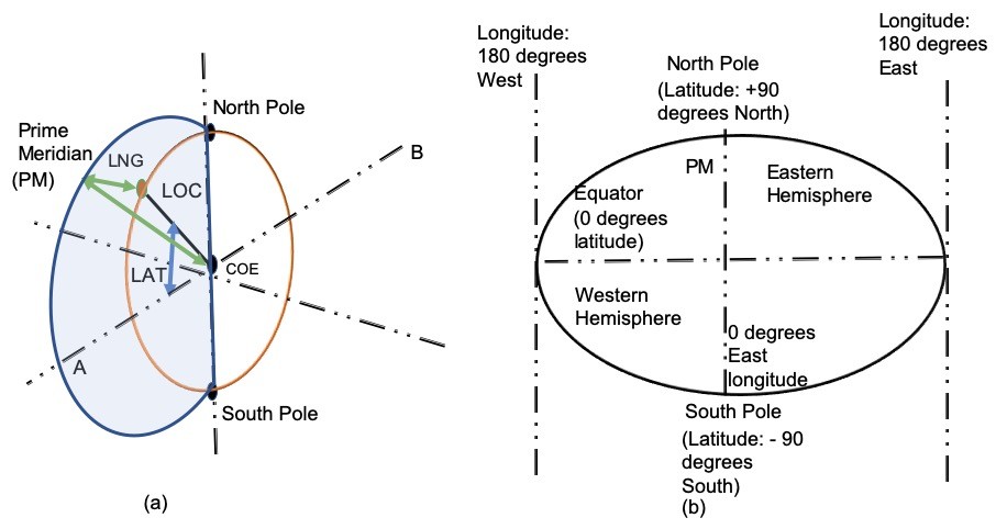
Image 2 (Latitudes and Longitudes)
What is Latitude?
Let us consider a location LOC somewhere on the Earth as depicted in Image 2(a). Let us take it to be in the North-East Hemisphere so that you can visualize it in a 3D view. If we join a straight line from COE (Center of Earth) to LOC (orange point), the location will form an angle with the Equator which will pass from the center of the Earth in a horizontal direction.
The latitude is highlighted as LAT in Image 2(a) which is an angle. It is important to note that the LOC will fall on a Parallel. Parallels of latitude help in identifying a location North or South of the Equator. The North and South poles are considered perpendicular to the equator and can be considered a reference for calculating latitude LAT. Here, LAT is Northern Latitude as it is in the Northern Hemisphere.
The Equator is considered to have 0 degrees latitude, while Poles are at 90 degrees latitude North or South (90° N or 90° S), depending on the North or South Pole.
To summarize, Latitude is a coordinate (geographical coordinate) of a place on Earth. To be more precise, Latitude is what enables us to determine if a location is in the Northern or Southern Hemisphere of the Earth with the Equator as the reference point.
Latitude is often denoted by Greek letter phi (φ or ϕ)
A parallel of latitude is considered to be the “near” circular virtual line around the Earth touching locations having the same latitude.
What is Longitude?
The virtual and “near” semicircular lines or meridians relate to the longitude. These meridians meet the North Pole, and South Pole, and intersect the Equator. In Image 2(a), Prime Meridian is the reference line (blue semicircular line) from which the longitude is derived. It dissects Earth and identifies a location in the Eastern or Western Hemispheres of Earth. Thus, longitude can have angles between 0 and 180 degrees each in the Eastern and Western Hemispheres.
The location LOC in Image 2(a) is to the right of the Prime Meridian or in Eastern Hemisphere as per the assumption of the North-East hemisphere that we took at the start.
The angle formed between the Prime Meridian and the Meridian (here the orange circular line) passing through the concerned location LOC, denotes the longitude of that location. In Image 2(a), for location LOC, the longitude is depicted as LNG. As already stated earlier, the Prime Meridian is considered to have 0 degrees longitude.
The 2D view depicted in Image 2(b) shows the values of latitude and longitude of the North Pole, South Pole, and Equator. Here, Prime Meridian (PM) is considered to be the centerline passing through the North and South poles.
To summarize, Longitude is a coordinate (geographical coordinate) of a place on Earth. To be more precise, Longitude is what enables us to determine if a location is in the Eastern Hemisphere or Western Hemisphere of the Earth, where Eastern and Western Hemispheres are derived with reference to the Prime Meridian.
Longitude is often denoted by the Greek letter lambda (λ).
Measurement Units of Latitude and Longitude
Till now, it would have been clear that a location on Earth can be defined using both Latitude and Longitude combined. Longitude and Latitude intersect to form virtual grids on the Earth where a location can be identified.
Latitudes and longitudes are both defined in degrees, minutes, and seconds. An important thing to note is that the minutes and seconds here are not concerned with units of time. As discussed above, Latitude ranges from 0 – 90 degrees North and 0 – 90 degrees South. Similarly, Longitude ranges from 0 – 180 degrees East and 0 – 180 degrees West.
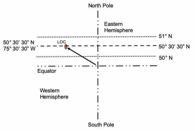
Image 3 (Units: Latitude and Longitude)
Example of Latitude and Longitude
Let us consider Image 3 and keep LOC in the North-West hemisphere this time.
If we rely only on Degrees, it will not be much helpful to identify the concerned location as there are a decent number of kilometers between each degree when we talk about latitude and longitudes.
The distance between each degree of latitude is almost 111 km. So, between latitudes 50° N and 51° N, there will be a distance of 111 km.
Thus, we require more drilled-down units and mechanisms to help in identifying a particular location. That is where minutes and seconds come in.
A Degree is divided into 60 parts, and 1/60th part is called a Minute. So, there are 60 Minutes in a degree. So, between every minute, we will have a distance of 1.85 km (111/60) latitude.
Each Minute is divided into 60 Seconds (Minutes and Seconds units follow the same rule as in time, but here they are related to location.)
Considering Image 3, the LOC is exactly halfway in between 50° N and 51° N and thus can be represented as 50° 30’ N. Now, if we drill down further, and the location is between 50° 30’ N and 50° 31’ N, then it can be represented as 50° 30’ 30” N.
Considering longitude, the exact location can be represented as 75° 30’ 30” W. Thus location is in the North-West part of the Earth. The location can also be identified only in degrees. Considering 50° 30’ 30” N, this can be represented as 50 + 30 * (1/60) + 30 * (1/3600) = 50+0.5+0.008 = 50.51° N.
When we speak and write, Latitude is always used first followed by longitude.
Latitude of important reference points
| Location | Latitude |
| Arctic Circle | 66°33′48.2″ N |
| Antarctic Circle | 66°33′48.2″ S |
| Tropic of Cancer | 23°26′11.8″ N |
| Tropic of Capricorn | 23°26′11.8″ S |
Latitude and Longitude of few cities around the globe
| Place | Latitude & Longitude |
| Sydney, Australia | 33°52′S 151°13′E |
| Washington, US | 38°54′N 77°02′W |
| Paris, France | 48°51′N 2°21′E |
| London, UK | 51°30′N 0°08′W |
| Mumbai, India | 18°59′N 72°50′E |
| Tokyo, Japan | 35°41′N 139°42′E |
That is it. Though the topic of latitude and longitude is vast and contains much more, this basic information should be good enough for an overview. I hope it helps. Let me know your thoughts in the comment section below.
Latitude and Longitude are used as part of the Geographic Coordinate System that enables every location on Earth to be referenced via numbers and symbols.
Using Google Maps, today, you can easily find the geo-coordinates of a place.
Check out the coordinates of different places using the map coordinates website.
Good Reads & References
Images are subject to Copyright @ The Unprecedented Cult
CURATED & WRITTEN BY
AYUSH PANDYA
(AUTHOR – THE UNPRECEDENTED CULT)